Find water (Depth & Yield) Before you drill
AquaLocate is the premier provider of water well locating solutions in the industry. Before drilling begins, our technology can determine if groundwater is present and give you the information needed to help plan the cost of your drilling project.
Minimize Drilling Costs
Well drilling contractors charge for every hole they bore, even if it is dry or has a low yield. For an average well, you can expect to pay $6k to $12k (or more). Most of our groundwater surveys are priced at 15 to 20% of the cost of an average well and have a very high success rate.
Save Time
AquaLocate's technology gives you the answers you need to have a better strategy for your drilling project. The GF6 will help prevent wasted time, effort and costs associated with drilling multiple holes to search for water. Ask us about drilling contractors who use our technology as part of their drilling services.
Depth & Yield
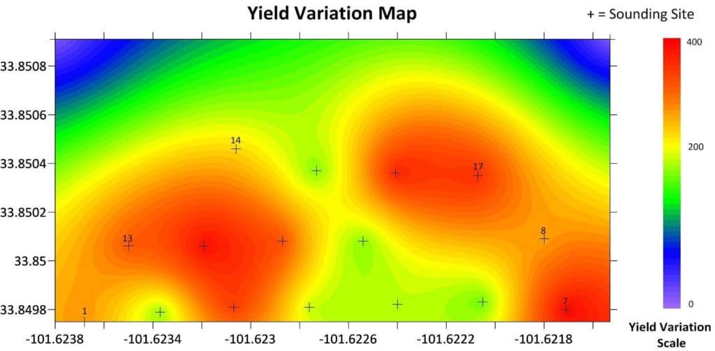
The GF6 systems/surveys can provide both depth and yield estimates by directly imaging groundwater (mobile resistive liquid), whereas traditional exploration tools simply image the geologic structure. The GF6 can detect groundwater to depths beyond 1600ft.
WHO WE HELP
AquaLocate can help anyone in need of locating water underground (aquifer). Our primary customers are landowners seeking to find the correct location to drill a new or replacement water well. However, our technology has been used by geologists, hydrogeologists, geophysicists, drilling companies, land developers, military and more.
AGRICULTURE INDUSTRY
We help farmers find the best solutions to maintain their crops and livestock by locating sufficient groundwater for existing or planned irrigation systems.
NON-PROFITS
Non-profit organizations in Kenya, Guatemala, Mexico, Tanzania, Haiti, and Uganda use our technology to help communities by finding fresh water in locations that previously did not have a fresh water source.
RESIDENTIAL WELLS
We find water for homeowners and landowners seeking a location to drill a new water well. We provide feasibility studies to future home/land owners, realtors and developers prior to purchase.
our PROCESS
Groundwater surveys are performed by AquaLocate and its affiliates on location using the most advanced seismoelectric instruments and equipment. We are the exclusive worldwide manufacturer and distributor of the patented GF6 Seismoelectric System and we offer equipment sales and training to new operators. Our technology’s ability to detect liquid at extreme depths and create accurate images of groundwater patterns has made it useful for many different kinds of projects from scientific studies to large-scale development projects.
What to expect from a GF6 exploration survey
An exploration survey typically consists of six or more soundings collected in an organized fashion with not more than about 100 feet between each sounding. A sounding is what we call each test site completed. As we increase the number of soundings recorded on any given area, detail and accuracy increases. Additionally, the more testing we complete the greater the chance we will find the groundwater source for which the property owner is searching.
AquaLocate takes the guess work out of trying to find the right location (depth & yield) for your new well before drilling begins.
The GF6 provides accurate depth estimates with the capability of imaging fresh groundwater to depths exceeding 1600 feet.
AquaLocate can offer information and advice to those intending to drill a new borehole.
AquaLocate can assist in determining the feasibility of a well restoration project.
DATA REVIEW & interpretation
After the soundings are completed on-location, the operator uses our advanced analyzing software to review and interpret the data. The information is then translated it into reports or 2D profiles and maps (depending on project requirements).
New operators go through training to learn basic data interpretation and we also offer data review to operators of our technology when requested.
- Yield Prediction Reports
- Depth & Thickness Report
- Permeability Profile
- Contour Map Development
- Mapping Problem Zones
- Water Table Delineation